Lower Cedar River HEC-RAS 1D/2D Modeling
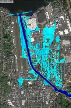
As part of the Cedar River Corridor Plan, the lower 2.6 miles of the Cedar River were modeled for both the current condition (with significant sediment aggradation) and a proposed dredged condition. This analysis was conducted to provide planning level hydraulic analysis to support a capital improvement strategy for the Cedar River and provide insight into the improvements that would be necessary to contain the 500-year flow along this highly urbanized reach of the river.
Role/Services: WSE developed flood hydrographs for the 100-, 200-, and 500-year events by scaling data from the January 2009 flood at USGS gage 12119000 - Cedar River at Renton, WA. A HEC-RAS 1D/2D model geometry was developed for both the existing and post-dredge conditions by merging surveyed and proposed channel cross-sections (respectively) with existing LiDAR-derived topographic data. The model was used to assess the 100-, 200-, and 500-year flows and the incipient overtopping condition for pre- and post-dredge geometries to assess the location, extent, and depths of overbank flooding. Results of the modeling were used to evaluate potential levee and bank improvements and bridge modifications to determine the level of flood reduction provided by different alternatives
Outcome: The analysis determined that minimal flooding would occur at the 100-year event, but significant bank overtopping would occur in the 200- and 500-year events. To fully contain the 500-year event within the channel the banks would need to be raised significantly, and several bridges would need to be raised by an average of 3 feet. This hydraulic modeling and analysis will be used by the County to prioritize future capital improvement projects.
